The Neiss Report was also published in the February Issues
of The Bigfoot Times and in the Bigfoot_Newsletter_Online #42.
Multnomah County, Oregon
In the spririt of sharing...
On January 11th, I investigated a report received on Wednesday, January 9th, of a sighting of a Bigfoot that took place along I-84 between mileposts 27 & 26 around 9:30pm of that same day. The following is a brief summary...
I arrived on scene
approximately 35 hours after the initial sighting, parking first at the
Bridal Veil Post Office at exit 28. Although the witnesses claimed the
sighting was between mileposts 26 & 27, I felt it best to expand the
investigation site as it was dark (9:30pm) when they had their encounter.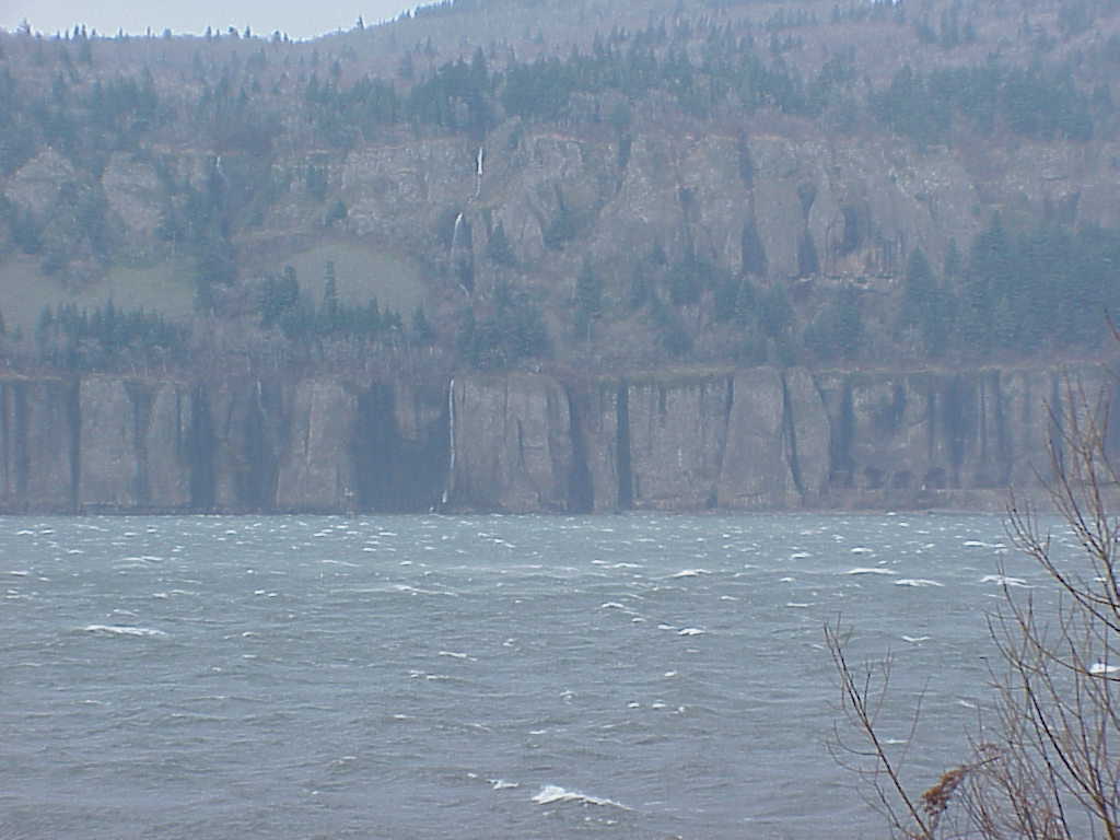 Interstate 84 runs East-West and parallels the Columbia River through
the scenic Columbia River Gorge.I proceeded to cross the interstate in
order to inspect the Columbia River shoreline for any evidence. The winds
were blowing out of the Gorge at a constant 40 mph (with gusts reaching
60+) and the river was tossing 3 foot white-capped swells westward towards
the Pacific Ocean 100 miles distant. Upon reaching the river, I proceeded
west until I was blocked by Bridal Veil Creek where it drains into the
Columbia River (it was flowing fairly fast and wide). The shore line consisted
mainly of rocky terrain covered with mattes of grasses and sticks swept
across the waters and tossed up on the beach (not the greatest medium
for taking tracks). While this stretch of shoreline produced no tangible
Bigfoot evidence, I did discover one amusing article...a Frisbee emblazoned
with the "Animal Planet" logo (those guys are everywhere I tell
ya).
Interstate 84 runs East-West and parallels the Columbia River through
the scenic Columbia River Gorge.I proceeded to cross the interstate in
order to inspect the Columbia River shoreline for any evidence. The winds
were blowing out of the Gorge at a constant 40 mph (with gusts reaching
60+) and the river was tossing 3 foot white-capped swells westward towards
the Pacific Ocean 100 miles distant. Upon reaching the river, I proceeded
west until I was blocked by Bridal Veil Creek where it drains into the
Columbia River (it was flowing fairly fast and wide). The shore line consisted
mainly of rocky terrain covered with mattes of grasses and sticks swept
across the waters and tossed up on the beach (not the greatest medium
for taking tracks). While this stretch of shoreline produced no tangible
Bigfoot evidence, I did discover one amusing article...a Frisbee emblazoned
with the "Animal Planet" logo (those guys are everywhere I tell
ya).
I returned to my vehicle
and merged back onto I-84 heading west this time, stopping at milepost
27. Once again I clambered down to the shoreline and headed back upstream
until I reached the opposite side of Bridal Veil Creek and picked up where
I had left off. Most of the shoreline remained as before, until I reached
a point about halfway between mileposts 27 & 26. There, it evolved
into a fairly decent sand-covered trail paralleling the shoreline. This
made tracking much easier and I soon began spotting tracks from various
animals such as deer, canines and people. I took the time to photograph
every type of track, including my own, for comparative analysis. About
200 yards along the sandy trail, I discovered one unusual track.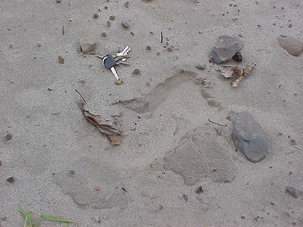 It was about 13" in length x 7" wide at the "toes"
and appeared to be made by something quite heavy. It lacked any sort of
tread design and had no stepped heel indentation. In addition, it flared
disproportionately wider than a human track. The track appeared to be
coming from the interstate and heading directly towards the river. It
merely crossed the sandy path and so I had difficulty locating any clear
accompanying tracks to correspond with it. I continued up to milepost
26 and then retraced my route back to the interstate. I found no other
good candidates for Bigfoot tracks or any other evidence for that matter.
I have embedded
a photo of the track for your own interpretation. -->
It was about 13" in length x 7" wide at the "toes"
and appeared to be made by something quite heavy. It lacked any sort of
tread design and had no stepped heel indentation. In addition, it flared
disproportionately wider than a human track. The track appeared to be
coming from the interstate and heading directly towards the river. It
merely crossed the sandy path and so I had difficulty locating any clear
accompanying tracks to correspond with it. I continued up to milepost
26 and then retraced my route back to the interstate. I found no other
good candidates for Bigfoot tracks or any other evidence for that matter.
I have embedded
a photo of the track for your own interpretation. -->
I followed a well
used game trail back to the interstate where I found notable damage to
a barbed-wire fence perfectly aligned with the game trail. The post and
a small section of the fence was bent over towards the river. Could this
have been the creature's avenue of egress to the river? Possibly. This
too was photographed.
In conclusion,
I came away with a potential scenario\route for the creature. I suspect
the game trail may have been utilized by the Bigfoot, and the fence damage
a possible result of it's crossing. I did inspect the barbed-wire for
traces of hair, but found none. The location of the damaged fence, game
trail and "track" correspond with the eyewitnesses account.
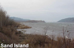 It
should be noted that there have been other reports from that same area
in the past and it is speculated that this may be a potential river crossing
point, as Sand Island is located mid-river at this point, providing a
potential resting stop midstream.
It
should be noted that there have been other reports from that same area
in the past and it is speculated that this may be a potential river crossing
point, as Sand Island is located mid-river at this point, providing a
potential resting stop midstream.
If you require additional
information or should your ISP not support embedded pictures, feel free
to write me and I will be happy to respond and\or send the photo as an
attachment.
Posted Note in March 6, 2002
"In January, I posted a report dealing with my investigation of a
sighting that took place along Interstate 84 near Rooster Rock, OR. While
I inadvertantly forgot to credit my sources, I would like to do so now
in the spirit of good journalism. I
was originally alerted by Dennis Fenton and Rob Johnson III, who in turn,
gleaned it from a report initially posted to the BFRO website. I wish
to compliment them as well as Thom Powell for his refreshing openness.
Let's keep the spirit of sharing flowing!"
Best Regards,
Todd M. Neiss
Executive Director
American Primate Foundation
Mt. Hood, Oregon
Additional Note March 10: Thom Powell contacted the witness by cell phone
on the 9th of February. Todd Neiss did the onsite investigation February
11th; Ray Crowe also did an onsite investigation.
I think that pretty much covers it correctly, right? Who did I forget?
B.Short